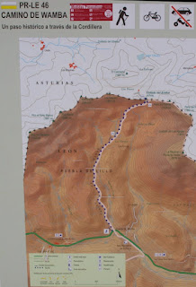
Distance: 5.3 km each way
Total ascent: 260 m.
Duration: 3 hours 25 minutes out and back.
Maps: IGN
79 (14-06) Puebla de Lillo (1:50,000)
Route: PR-LE 46
1. From the
San Isidro car park, walk approximately 1.5 km east along the main road,
towards Puebla de Lillo, until the bridge over the Wamba river on a right-hand
bend.
2.
Alternatively
try parking near this start.
3.
The path
starts on the left here; there is a descriptive signpost.
4. Follow
the track on the left hand side of the river, for approximately a kilometre and
a half, before bearing right at the top of the river.
5.
Continue
to the col, the Collada l’Acebal, at 1711 metres.
6.
From here
there are options to climb nearby mountains such as El Cascayón.
7.
Return
the same way to the road.
8.
Note that
the route may vary in the snow, this is reflected in the GPS track shown which
does not always follow the track.
Below is a map of the route, based on a GPS track. To see the route in 3D, click on the Earth button.
